
Climate
Climate
John Constable
John Constable
Why do you think climate is important in permaculture?
Why do you think climate is important in permaculture?
Greenhouse gases, such as carbon dioxide and methane, trap heat because they allow the sun's rays to enter the atmosphere but do not allow the resulting heat to leave the atmosphere. The amount of these gases in the atmosphere determines the earth's average temperature. In contrast to the previous 13°C, now the average temperature on the planet is 14°C. The reason is the active use of fossil fuels. The increase in the earth's average temperature due to greenhouse gases is called global warming.
150 years ago, humans did not create many greenhouse gases. As the number of people on Earth increased, we began to cut down forests to build cities and farms. The world also changed as a result of scientific and technological progress. These inventions and technologies consume large amounts of energy, and most current energy comes from fossil fuels: coal, natural gas, and oil.
150 years ago, humans did not create many greenhouse gases. As the number of people on Earth increased, we began to cut down forests to build cities and farms. The world also changed as a result of scientific and technological progress. These inventions and technologies consume large amounts of energy, and most current energy comes from fossil fuels: coal, natural gas, and oil.
Fossil fuels come from soil and water plants and animals that lived millions of years ago. The fuel we use in cars is part of living organisms. But how did carbon accumulate in fossils? 500 million years ago, all the carbon, which was to be transformed into plants and animals in the future, was in the air (in the form of carbon dioxide), which is why the average temperature on earth was 30-40°C. As plants evolved, they began taking in carbon dioxide from the atmosphere to make their leaves and stems. Carbon also entered the body of animals by eating plants. Over time, these plants and animals died, and the carbon inside them went underground, where it turned into a mineral under the conditions of temperature and pressure. By burning fossil fuels, we release the carbon locked up in the soil back into the atmosphere.
1
2
In order to cope with climate change, it is important to include a variety of plants in a permaculture project
When designing complete permaculture systems, it is important to consider the climate in which you live. When you know which part of the planet you are in, you can create a project that will suit the conditions of your residence. The climate is the long-term pattern of weather in a particular location and is obtained as a result of averaging weather conditions over several consecutive years. The climate is generally classified based on temperature and precipitation. The Köppen climate classification is the most popular model, which divides the climate into 5 main climate groups: A (tropical), B (dry), C (temperate), D (continental), E (polar).
The climate in Armenia varies from the cold desert climate in the lower parts of the Araratian fields to the polar climate on the mountain peaks. Looking at the map below, you can find out what climate zone your place of residence is in.
1
2
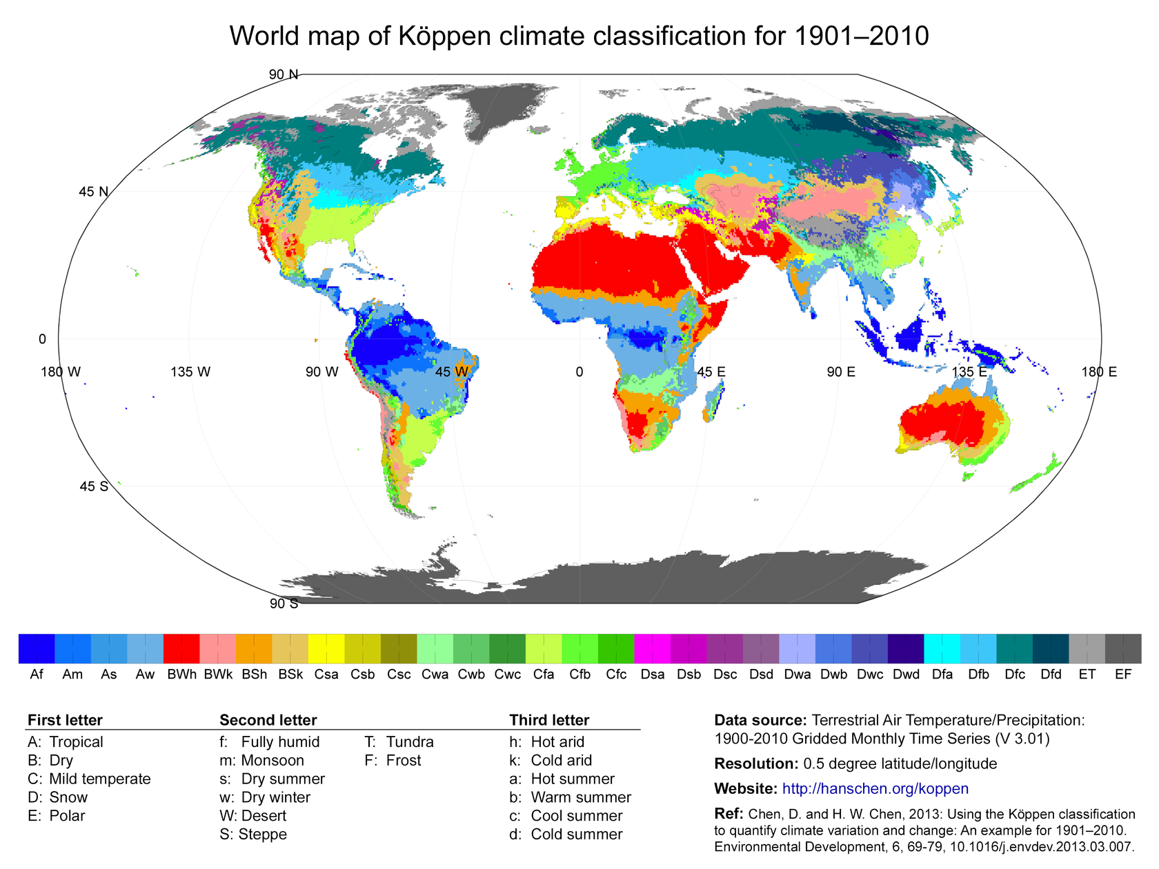
The Köppen climate classification
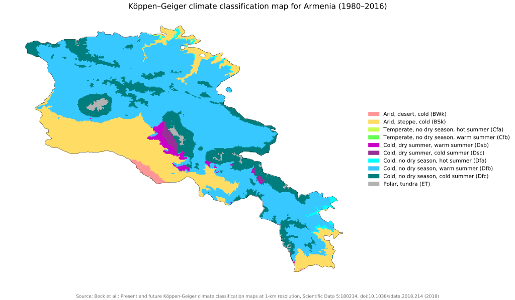
The Köppen climate classification in Armenia
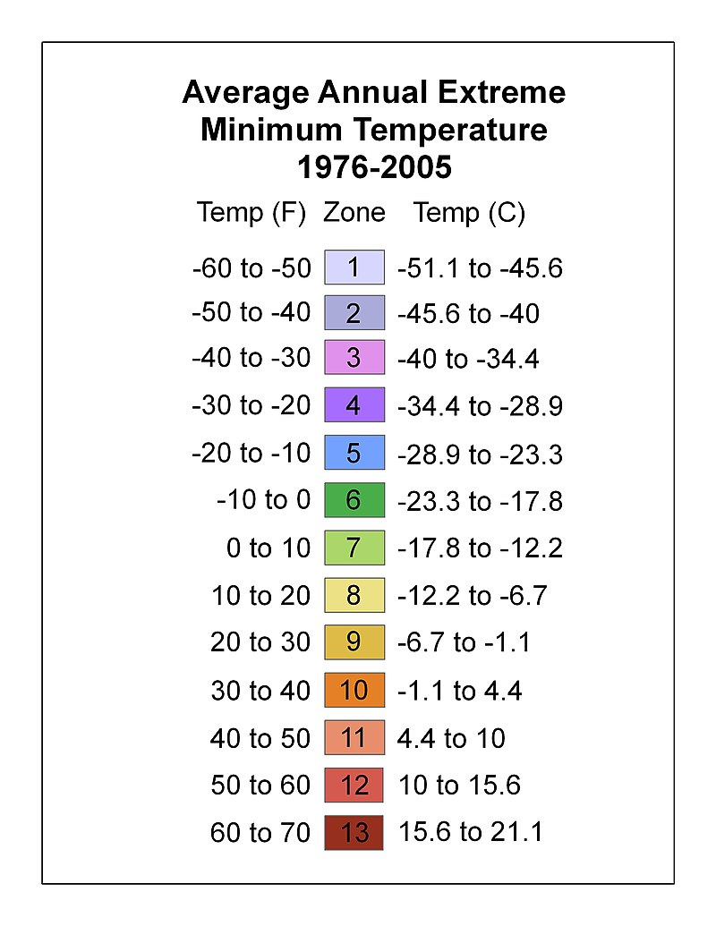
An important aspect of climate is the average minimum temperature, which determines what plants can be planted in a given zone. It determines the necessary level of frost resistance in the area. There are 13 zones divided by minimum temperature. In the first zone, the temperature can reach up to -50°C. Siberia and Alaska are in this zone. Zone 13 is the warmest. The annual minimum temperature here is 16°C. Puerto Rico is located in this zone. Most of the territory of Armenia lies in zones 4-6. When you want to understand what plants can grow in your zone, Google ""plant name in English," hardiness zone." For example, apricots grow in frost resistance zones 4-9; that is, it can grow in the entire territory of Armenia. Pomegranate grows in zones 7-10. That is, it can be grown in border regions of the RA territory, such as Meghri and Noyemberyan.
3
3
4
A microclimate is a climate specific to a small area, for example, under a tree, on a roof, next to a large rock facing south, etc. The climate of these small areas can differ significantly from the climate of the larger regions that comprise them. For example, if you live in Yerevan in hardiness zone 6 and want to grow a pomegranate against a south-facing wall, it will probably survive even though they grow in zones 7-10. The reason is that during the winter, the wall will accumulate heat from the sun during the day and will slowly release this heat at night. As a result, the minimum temperature of the microclimate of that small area next to the wall and around the tree will be equivalent to the 7th cold hardiness zone.
The main factors affecting the microclimate are:
- access to the sun
- the wind
- soil type
- air and soil moisture
- the influence of surrounding plants and buildings: emissions of toxic substances, heat radiation, etc
Marisha Auerbach is a permaculturist living in Portland, Oregon, USA. Marisha's house is in a tree-lined neighborhood, a little far from the city center. When designing the garden, Marisha created a microclimate map that played a key role in her permaculture design. For example, in the hot south, he plants heat-loving plants. It also created its own microclimates. Using wrapping vines, Marisha shaded the roof of the house and turned it into a breezy microclimate and relaxation area. He also grows tall trees that create favorable microclimates for smaller plants and protect them from strong winds and dry, hot weather.
4

Marisha's garden
0:48-0:53 shows how these organisms create soil structure.
As you understood from the video, Marisha pays a lot of attention to the sectors of her territory. It is important to create a sector map. In a permaculture space, sectors are energy currents that we can collect or block. Examples of sectors are the directions and effects of sun, wind, water, wildlife, scenery, and noise on the design area.
Aranya Farm in the Deccan Plateau of India is an excellent example of permaculture designed in desert climate soils. The farm has been built
by Narsanna and Padmé Coppola in the 1990s. They began the project with a map of sectors, which depicted the directions of water, wind, and fire; these three are the key sectors of the desert climate.
Include in your sector map:
- Midsummer and midwinter solstice, sunrise and sunset locations at different times of the year
- Prevailing wind direction: wind entering the permaculture area
- Areas prone to flooding or frost
- Fire hazard areas
- Directions for good and bad views from the area
- Other factors and their entry points, such as pollution, passers-by, noise, bright lights, smells, etc.
- Neighbors and possible problems arising in their area
- Rainwater harvesting capabilities - roof surfaces
1
2
3
Gathering the necessary information may take a full year. It is also useful to gather information from locals or frequent visitors to the area. This information will help you determine the current microclimates and manage the currents of energy.
Aranya farm
Sector map example


By your school visiting site during different seasons, also try to understand:
- Heavy rains - Where is the water collected, how does it run down the slope, is the rainwater catchment installed, where does the water collect (this could be a sign of soil compaction), is the water running over the soil brown in color? (a sign of erosion).
- Strong winds - What are the areas with a lot of wind, and what are the best-sheltered areas? If you place flags around the area, you will be able to understand the wind patterns
1
2
By visiting your school site during different seasons, also try to understand:
- Heavy rains - Where is the water collected, how does it run down the slope, is the rainwater catchment installed, where does the water collect (this could be a sign of soil compaction), is the water running over the soil brown in color? (sign of erosion).
- Strong winds - What are the areas with a lot of wind? What are the best-sheltered areas? If you place flags around the area, you will be able to understand the wind patterns.
1
- Frostbite - Which areas are frostbitten? Can cold air spread down the slope? Is it possible to fix this? Are there unfrosted areas near trees, plant barriers, and buildings.
- Snow - Melting snow is very useful for revealing hidden symbols.
- Roofs of heated buildings are worse insulated (more heat loss) if the snow melts quickly. Other microclimates, such as around buildings, also accelerate snowmelt. Conversely, colder areas will retain snow longer.
- Drought - When the rains stop, which areas suffer the most? Does soil compaction prevent water from entering the soil? How long does it take for the soil to dry out completely and the water reserves (in rainwater tanks, in the soil) to be depleted?
2
What did you learn about the role that climate plays in permaculture projects?
How do you think healthy soil can help us fight climate change?
Discussion 7: preparatory tasks
Complete the task before discussion 7 and come ready for the discussion.
1. Add sector map elements and your observations of possible weather patterns to your map by answering the questions in the reading material about heavy rain, strong winds, snow, frost, and drought. Send your map work to the trainer using the chat.
1. Add sector map elements and your observations of possible weather patterns to your map by answering the questions in the reading material about heavy rain, strong winds, snow, frost, and drought. Send your map work to the trainer using the chat.